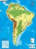
Amazon Basin
the Amazon Basin ( Amazonia ) is covered by the largest tropical rain forest in the world, and running through is heart is the amazon river , and its more than 1000 tributaries . Measurable rain falls on an average of 200 days a year, and total rain fall often approaches 100 inches per year.
Andes
Massive mountain system extends from the tip of South America all the way to panama. It is the source of most major rivers on the continent; it is home to some of the planets largest volcanoes. The highest point in the continent an Aconcagua in Argentina, at 6,960 m
Atacama Desert
Sparsely populated and running high into the Andes of Chile, this somewhat small desert is a cold place and rain fall is very rare.
Brazilian Highlands
This highland region-about 800 miles in length runs through the Brazilian state and the Southeaster Brazil. The highest point is 2245 m Sugar Loaf.
Guiana highland
The highlands stretch from southern Venezuela across the northern edge of South America to the tip of Brazil. It is fame for the highest waterfall in the world (angel falls) at 979m high.
Llanos
This large and fertile plain, located in eastern and central Colombia and central and southern Venezuela, is drain by the Orinoco River and many tributaries.
Pampas
This large plain in the southern are of the continent (Argentina) extends for 1600 km. The important landform is the Uruguay River.
Patagonia
Located between the Andes and the Atlantic Ocean, stretches south from the Rio Negro River to Tierra del Fuego and Strait of Magellan.
Picture related to these topics
Sources used to write the post
Bustos, J.(2011). Social studies seventh grade. Cartago: Saint Clare College.
Video related to these topics
External link related to these topics:
Social Studies Seventh Grade,Study Guide,book.